 Loading... Please wait...
Currency Displayed in

- Home
- Travel Maps
- Sweden SouthEast Travel Map
Categories
Related Products
-
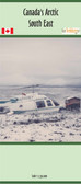 Arctic 6 Southeast map $18.95
 -
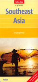 Southeast Asia Travel Map $11.95
 -
-
 Finland Sweden Travel Map $12.95
 -
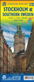

Sweden SouthEast Travel Map

Hover over image to zoom
)
Product Description
Freytag folded road and leisure map of Sweden Southeast including Stockholm, Uppsala and Norrkoping with major sights of interest, distances in km & camping sites. Great quality map to buy for your travels through southeastern Sweden.
Sweden South-East: Stockholm - Uppsala - Norrköping area in a series of detailed, indexed touring maps from Freytag & Berndt with the southern and central part of the country at 1:250,000 and the north at 1:400,000. Relief shading and spot heights show the topography.
Road network includes what is confusingly described in the map legend as “private” roads, unsurfaced roads open to the general public but simply privately maintained, and indicates toll routes, restrictions and winter closures, steep gradients, motorway services, etc. Scenic roads and special tourist routes are highlighted. Railways with stations, ferry services, and local administrative boundaries are marked. National parks and prohibited areas are highlighted and symbols show places of interest, campsites, mountain shelters, youth hostels, etc.
The maps of southern and central Sweden have latitude and longitude lines drawn at 10' intervals, with 30' on the two northern sheets. Multilingual map legend includes English. A place name index, with post codes, is provided in a booklet attached to the map cover.