 Loading... Please wait...
Currency Displayed in

- Home
- Maps By Sport
- Canoe Maps Canada
- Philip Edward Island - Georgian Bay Kayaking Map
Categories
Related Products
-

-
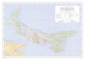 Prince Edward Island 1974 $24.95
 -
-
-
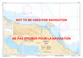

Philip Edward Island - Georgian Bay Kayaking Map

Hover over image to zoom
)
Product Description
The north coast of Georgian Bay is considered to be among the most beautiful of wild kayaking and camping experiences in North America. Thousands of small, beautiful islands, some having fantastic shapes, fresh breezes, easy access, relatively low numbers of users and the lovely quartzite hills of Killarney Provincial Park in the background, will all make your Philip Edward Island trip a truly memorable event.
This map covers the area from Thomas Bay a few kilometres west of Chikanishing River and the west park boundary, all the way east to Point Grondine, and from the George Lake campground in Killarney Provincial Park all the way south to the remote Scarecrow and Green islands. That's all of PEI, Collins Inlet, Beaverstone Bay and the south edge of Killarney Provincial Park.
At 1:30,000 scale, our 18x32 inch map shows the area in extraordinary detail, and includes the usual features of essential interest to paddlers. You'll find access points, campsites, portages, shoals and shallows, points of
interest, roads, hiking trails, detailed contours, and lots more, as well as text and colour photos describing the route, human and natural history, local attractions, safety considerations, and more.
This one is on waterproof plastic as usual, so paddlers can get it as wet as they like without it disintegrating! It can even double as a useful rain hat.