 Loading... Please wait...
Currency Displayed in

- Home
- Maps By Sport
- Canoe Maps Canada
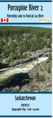
- Fond du Lac River Map Set
Categories
Related Products

Fond du Lac River Map Set

Hover over image to zoom
)
Product Description
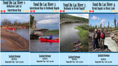
Map of Canoe routes of Fond du Lac River 1 2 3 4 Saskatchewan. scale 1:50,000.
Set of 4 maps of The Fond Du Lac River Area in North Central Saskatchewan, Canada. Wollaston Lake to Waterfound Bay, Waterfound bay to Redbank Rapids, Redbank to Brink Rapids & Brink to Black Lake. These maps are 27" x 40", 21" x 27", 41" x 15" & 34" x 21", shows suggested canoe routes, and route information with forest fire burns. Scale 1:50,000.