Loading... Please wait...

Categories

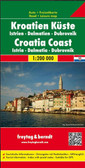
Dalmation Coast Travel Map

Hover over image to zoom

  • Dalmatian Coast "Top 10 Tips" Map at 1:150,000 from Freytag & Berndt with a booklet containing an index, brief descriptions of region’s 10 most popular destinations, plus street plans of Dubrovnik’s Old Town and central Pula, Rijeka, Split, Sibenik and Zadar. 

The map is double-sided and presents the region in three sections, as indicated on our area coverage image (NB. Istrian Peninsula is included). Topography is shown by relief shading with spot heights, with plenty of names of mountain and hill chains, etc. National parks and other protected areas are clearly marked. Road network includes small local roads and selected cart tracks, and indicates motorway services, routes closed to traffic or not recommended for caravans, seasonal closures, gradients for steep roads, tourist routes and scenic roads, etc. Railways and ferry routes to the islands are marked. 

Picturesque towns and villages are highlighted and the region’s 10 top sights are prominently marked, with brief descriptions provided in a booklet attached to the map cover. Symbols mark other places of interest and facilities, including campsites and youth hostels, marinas, golf courses, museums, churches and castles, viewpoints, etc. Latitude and longitude lines are drawn at intervals of 10’. 

The booklet attached to the map cover also includes an index listing all localities with their postcodes, plus street plans of Dubrovnik’s Old Town and central Pula, Rijeka, Split, Sibenik and Zadar. Map legend, conveniently shown on both sides of the map, and the descriptions include English.
Freytag
$11.95
SKU:
AK7404
Weight:
0.20 KGS

 Product Description

Freytag double-sided, folded road map of the Dalmatian Coast with Rijeka, Cres, Krk, Koronati Islands, Zadar and Split at 1:150,000 with attached booklet containing information on the top ten sights for the area, city maps for Dubrovnik, Pula, Rijeka, Split, Sibenik and Zadar, index with postal codes and colour photos. A quality travel map to buy for your vacation on the Dalmatian Coast.

Dalmatian Coast "Top 10 Tips" Map at 1:150,000 from Freytag & Berndt with a booklet containing an index, brief descriptions of region’s 10 most popular destinations, plus street plans of Dubrovnik’s Old Town and central Pula, Rijeka, Split, Sibenik and Zadar. 

The map is double-sided and presents the region in three sections, as indicated on our area coverage image (NB. Istrian Peninsula is included). Topography is shown by relief shading with spot heights, with plenty of names of mountain and hill chains, etc. National parks and other protected areas are clearly marked. Road network includes small local roads and selected cart tracks, and indicates motorway services, routes closed to traffic or not recommended for caravans, seasonal closures, gradients for steep roads, tourist routes and scenic roads, etc. Railways and ferry routes to the islands are marked. 

Picturesque towns and villages are highlighted and the region’s 10 top sights are prominently marked, with brief descriptions provided in a booklet attached to the map cover. Symbols mark other places of interest and facilities, including campsites and youth hostels, marinas, golf courses, museums, churches and castles, viewpoints, etc. Latitude and longitude lines are drawn at intervals of 10’. 

The booklet attached to the map cover also includes an index listing all localities with their postcodes, plus street plans of Dubrovnik’s Old Town and central Pula, Rijeka, Split, Sibenik and Zadar. Map legend, conveniently shown on both sides of the map, and the descriptions include English.

 Find Similar Products by Category

You Recently Viewed...


newsletter

Copyright 2024 GoTrekkers. All Rights Reserved.
 Sitemap | Ecommerce Website Design by High Country Web Design.